Day One:
The big day finally arrived for our "shake down" backpacking trip planned for two or possibly three nights, but at least three full days. The last backpacking trip I did was in July 2009 to Mt. Whitney, so it's been a while. Sandi completed a 15 day supported trek on the Tahoe Rim Trail two years ago, where meals were brought in by Trail Angeles and she carried only snacks and essential gear, so this would be a new experience for her.
We met early Saturday morning at the Donner Pass Trail Head where I dropped off the Jeep and then Sandi's husband, Bob, drove us over to Lake Tahoe to Barker Pass Road, about an hours drive. Barker Pass Road climbs up to the Barker Pass Trail Head with an elevation gain of about 1500. Whew, that is 1500 feet I won't have to hike up! The segment of the PCT to Donner Pass to the north is about 32 miles. Its a good route to trek as "shake down" route because there are several close" bail out points" to major roads and areas should the need arise.
Our 32 mile hiking route starts a little below the yellow line at the bottom of the map (I forgot to turn the GPS on at the very beginning) and ends a little off the top of the map. The big blue area on the right is Lake Tahoe.
The Barker Pass Trail Head is one of many access points to the PCT and it is also one of the access points to the Tahoe Rim Trail (TRT, 165 mile trail around Lake Tahoe which I previously hiked and backpacked). The PCT and TRT are one and the same for about 5 miles and then the PCT splits off and continues on into the Granite Chief Wilderness. I've hike the first 5 miles several times following the TRT towards Blackwood Canyon, a gorgeous hike this time of year.
We look pretty fresh as we start off on this adventure.

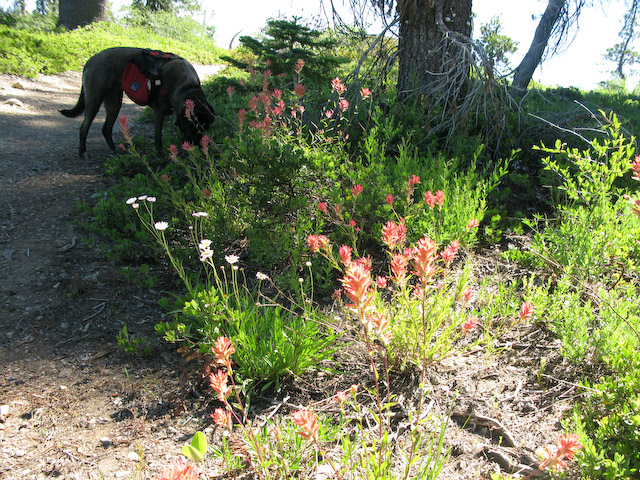
Armed with printed out maps from the Half Mile PCT website, an official Pacific Crest Segment Map, and my trust GPS, Sandi and I were able to hit the trail by 9:30. I was really looking forward to the first five miles having remembered all of the beautiful wildflowers from times before. Rio, Jeremy's dog, was excited and was her "happy dog" self every time she met up with new people and new dogs. She just loves people and dogs. With it being a Saturday, there were lots of folks out day hiking with their dogs.
At this point the PCT splits off from the TRT.
Lots of wild flowers along the trail.
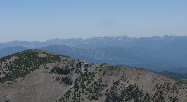
And many vistas to be enjoyed.
Below: Looking north. The pointy peak in the distance is Tinker Knob and to the left Castle Peak near the ending point of our trek and destination for Monday.
Below: Views of Lake Tahoe in the distance upper right of the picture. Fires in California have made everything hazy.
This is looking towards Incline Village, NV

Once the trail split off into the Granite Chief Wilderness, I was in new territory. Our goal was to make it to Five Lakes near the ski resort of Alpine meadows for the night. We found a stream and a good campsite about a mile from Five Lakes and decided to camp there instead of going the extra mile or so off the trail to Five Lakes, thinking it would be less crowded and probably less mosquitoes. The people were scarce, but the bugs weren't. The stream was perfect for soaking our feet and a good water source. It was a good day, with 11 miles under our belt, the last mile or so going straight down. Rio was really tired and really wanted in my one person backpacker tent. I finally give in, and she made herself comfortable and didn't move much in the night, except for shivering. I think the temperature dipped down to the low 40's.
Day Two:
The next morning was off to a slow start. I was cold and didn't want to get out the nice warm sleeping bag and Rio wasn't moving and there were no sounds coming from Sandi's tent. I finally rolled out of bed and got the water boiling for coffee. I have to hand it to Starbucks, their Via coffee is really, really, good for instant coffee and perfect for backpacking. It got me going. After coffee and oatmeal we finally broke camp and got on the trail sometime around 9:30, which is late for backpacking.
The trail continued through the Granite Chief Wilderness and skirted behind Alpine Meadows and Squaw Valley ski areas. There was lot of of elevation loss and then of course elevation gain. Our goal was to make it close to Tinker Knob, about 10 miles. The trail took us around the back side of Alpine Meadows and Squaw Valley Ski resorts. We descended down to 7500 feet into a valley and found another water source and place to camp about two miles below Tinker Knob. (Why does it seem we always camp at the bottom with a climb out in the morning?)We had only hiked about 8 miles, but it seemed like 18. We decided not to tackle the two mile hike of 1500 foot elevation gain up to Tinker Knob, but wait until the morning when it would be cooler. Sandi retreated to her tent right after dinner and I occupied my time reading IBooks on my Iphone and fighting with Rio over whether or not I would let her in the tent. Guess who won?
Twin Peaks are the two little knobs in the far distant, which is where we were the day before and about where the PCT and TRT split:
There were lots of meadows of Mule Ears. Some of the meadows were in bloom, but in this section it looked like they had peaked as the blooms were starting to wither.
There were lots of interesting dead trees bleached out by the harsh weather conditions.
One of the PCT markers, which were far and few between, and often past a critical intersection (one of my pet peeves).
Looking back to where we have been:
This is Tinker Knob, major land mark and destination for the day. We ended up camping in the valley below it where there was water.
Day Three:
The next morning everyone was refreshed and we were able to get up and get organized and on the trail by 7:30. That's more like it. It was to be a 14 mile day. Tinker Knob was only two miles away at an elevation of 8900. Ugh! The climb up was a challenge but the scenery was beautiful. There was a fast breeze which was almost too cool, and once on top it was smooth sailing with a gradual decent for the next eight miles or so. The trail follows the ridge and there are 360 degree vistas. It skirts around on the back side of Sugar Bowl Ski Resort near Mt. Lincoln and Mt. Judah where the trail starts to descend again back down to 7000 feet near Norden and old highway 40.
It was pretty warm by the time we got to the bottom of Mt. Judah where the trail abruptly ends onto a dirt road. We made a wrong turn and a foot path and soon decided it was wrong and turned around. There was a big PCT sign describing the area but no arrows pointing which direction to take on the dirt road until you traveled down it a few feet past a junction. We still had another four miles to go up over Donner Summit and the next four miles seemed to go on forever. There were lots of ups and downs and short, steep switch backs; it was hot; and we were all tired. Rio, poor thing, would leap frog to what ever shade she could find and wait until I passed her and then follow just as it looked like I would get out of her site.
This shows where we have been and the valley we camped in at the base of Tinker Knob
The trail climbs about 1500 feet over two miles at this point.
Our goal is to get to the top
Looking down at the trail I have just walked on.
The two little specs near the top are Sandi and Rio:
We made it! Tinker Knob is the highest point for us at 8,900 ft on this section of the the trail.
The trail continues for another 12 miles before reaching the Donner Pass parking area.
On top of the world! and walking along the spine...not for the faint of heart:
Looking back towards Tinker Knob:
Natures rock garden:
A good view of the trail:
First siting of Donner Lake
A snow patch near Sugar Bowl Ski Area around Mt. Lincoln. You can see some of the protective fence at the top of the picture, and it was a good place for Rio to cool off as she played in the snow.
Donner Lake and Rainbow Bridge near Old Highway 40.
We finally arrived at the parking area around 6:30 and the Jeep was still there. Wow, did it feel good to get my pack and boots off! Fourteen miles with a pack isn't too bad for us old folks! Poor Rio climbed into the back of the Jeep and didn't move until I dropped Sandi off at her house.
It was a good "shake down" trip which served its purpose. There was food left over, so I'll have to revisit how much to take next time. The goal is to keep the pack under 30 pounds which is a challenge while carrying a bear proof canister and enough food for an extended trip. For once I had just the right amount of clothing. Rio was able to carry enough food for three full days and carry some water, but her pack is not large enough to carry more, and I wouldn't want to put anymore weight on her. So, she'll have to stay home if I go for a longer period. Jeremy should be back soon.
Some have asked where's Joel while I'm doing this? Joel,... well he doesn't "do" hills, (LOL) so he is still in Oregon working on the Beaver.
What's next? Not sure. There will be a few "zero days" and then hit the trail. Stay tuned.
PS. Sorry this is such a long blog. It is soooo hard to determine which pictures to use; the scenery was so spectacular!